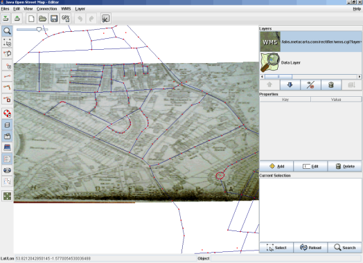
Here’s a plugin for the OpenStreetMap editing application, JOSM, that allows you to use WMS and in particular, Metacarta’s Map Rectfier. Get it here: WMSplugin.jar
Now that the Map Rectifier has the Mapnik OpenStreetmap layer, its possible to register, rectify and warp an uploaded image using the OSM data and then, using the WMS plugin to see the resulting image in JOSM.
I took a photocopy of a 1933 Ordnance Survey map of the Headingley area (you can just about see the cricket ground bottom left), and then, not having access to a scanner, took a mobile phone photo of that photocopy, and uploaded it to Map Rectifier.
Using the OSM layer, I was able to rectify the image, and experimented with a number of different warping options (think I settled on Quadratic Fit).
Since there is a WMS link to the warped image, I was able to alter the Landsat plugin in JOSM to make it show the rectified image.
This could allow you to digitize ways, label streets, fill in areas (like that cricket ground!)
The plugin is based on the Landsat plugin (with menus from osmarender plugin), with tweaks to get the URLs that are generated from the Rectifier working too. It should also work with any WMS too, and it defaults to Landsat. In theory it would be possible to see the Mapnik/Osmarender WMS in JOSM using this plugin too… might be useful?
The Plugin installs a “WMS” menu, with four items: 1) to set a fully formed WMS url, 2) to use a Map Rectifier URL, and 3) to default back to using Landsat. There’s also an option to get some information and help (4). You can also change the WMS url using the advanced preferences wmsplugin.url.
Of course, make sure that licence, terms of any WMS and the copyright of the rectified image covers use for OpenStreetMap.
WMSplugin.jar sources (zip) … (v1.0) however, expect to see changes as bugs are discovered and squashed.
—
Full WMS example:
http://onearth.jpl.nasa.gov/wms.cgi?request=GetMap& layers=global_mosaic&styles=&srs=EPSG:4326&ormat=image/jpeg
Metacarta Map Rectifier WMS URL input format example:
http://labs.metacarta.com/rectifier/wms.cgi?layer=image&
image=Image005.png-1165513186.tif
—


Pingback: OpenGeoData » Blog Archive » Some news
And what about laying a single GeoTiff image as background on JOSM? I have some very good quality images that would allow me to add easily data to OSM.
Do you think that it would be difficult to have such a plugin for JOSM?
Gari, thats a great idea!
Actually, it should ideally, be able to handle any georeferenced image format.
It shouldnt be that difficult for a plugin, one would have to make sure the images are in a suitable projection for josm however beforehand, i guess.
tim
Thanks for your answer! I finally got access to the WMS of the local government and it returns vertical (and corrected) image tiles. They gave me the permission to use it for OSM, so now I can edit drawing on the image!
Pingback: Mapping the Isle of Man | OMB
Pingback: mapmixer & rectifier « thinkwhere
Pingback: Blog of Blogs » Blog Archive » mapmixer & rectifier « thinkwhere
Pingback: First peek into the map warper project « thinkwhere
Hi,
Wonmderfull idea, but I tried to load an image of mi region Boyacá, Colombia calibrating with the OSM maps, but this map is unavailable in south america.
Thansk for your help in this problem .
Leonardo
Leonardo, Metacarta’s map rectifier is no longer being supported or developed, so I made a new one 🙂
http://wrp.geothings.net
and http://warper.freemap.in
Try this one and see if these help
tim thanks for your help
Hello, i think that i saw you visited my weblog thus i got here to return the prefer?.I am trying to to find issues to enhance my site!I assume its good enough to use a few of your ideas!!|